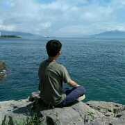
บรรยากาศอลังการ ช่างธรรมชาติ สวยงามมากของซินเจียง
;
Kuitun River Canyon Review
4.6 /572 รีวิว


5/5
Kuitun River Canyon
โพสต์เมื่อ 22 มิ.ย. 2020

1 คนกดไลก์ให้
Like
 5/5ยอดเยี่ยมข้อความเดิม
ถนนวงแหวนที่สําคัญบนถนน Duku ทิวทัศน์ก็ดี แต่นี่เป็นครั้งที่สองที่ฉันมา ฉันยังรู้สึกไม่น่าสนใจ ฉันแนะนําให้ไปที่ Duku Highway เพียงครั้งเดียว และมันก็น่าเบื่อเป็นครั้งที่สอง
โพสต์เมื่อ 20 ส.ค. 20210 5/5ยอดเยี่ยมข้อความเดิม
อย่าคิดว่า Kuitun River Grand Canyon เกิดจากผลกระทบของแม่น้ํา Kuitun สาเหตุของการสร้างแกรนด์แคนยอนทั้งหมดเป็นเพราะการเคลื่อนไหวของห้องใต้ดินทั้งหมด อย่ากังวลว่าคุณไปที่ Kuitun River Grand Canyon หรือ Anjihai Grand Canyon หรือ Hongshan Grand Canyon อันที่จริงลักษณะทางธรณีวิทยาของหุบเขาทั้งสามนั้นคล้ายกัน แต่อยู่ในส่วนต่างของตําแหน่งทางภูมิศาสตร์ ถ้าฉันแนะนํา ฉันจะแนะนําให้ไปที่ Anjihai Grand Canyon ครั้งแรก แน่นอนว่าไม่ว่าจะไปแคนยอนไหนที่สําคัญที่สุดคือเจออากาศดีๆ เท่านั้นที่อากาศดีสามารถถ่ายภาพความสวยงามต่างๆที่ธรรมชาติแกะสลักบนหุบเขาแห่งนี้ได้แม้จะเป็นร่องรอยของแม่น้ํา
โพสต์เมื่อ 15 มี.ค. 20203 5/5ยอดเยี่ยมข้อความเดิม
ตั้งอยู่ทางใต้ของเมือง Kuitun ห่างจากตัวเมือง 18 กิโลเมตร เนื่องจากการล้างน้ําหิมะของภูเขาเทียนซานเป็นเวลาหลายพันปี ทิศทางทางทิศเหนือและทิศเหนือมีความยาวประมาณ 20 กิโลเมตร ฐานกว้าง 100 ~ 400 เมตร และความกว้างของไหล่ในหุบเขา 800 ~ 1,000 เมตร สูงจากด้านล่างถึงไหล่ในหุบเขาถึง 200 เมตร มันน่าตกใจจริงๆเมื่อฉันเห็นมันในบันทึกการเดินทางของคนอื่น
โพสต์เมื่อ 4 ธ.ค. 20193 5/5ยอดเยี่ยมข้อความเดิม
Kuitun River Grand Canyon, located 20 kilometers southwest of Kuitun City, Ili Kazakh Autonomous Prefecture, is not open to Xinjiang Tourism Bureau because of its dangerous terrain. The Grand Canyon runs quietly in the upper reaches of Kuitun River, where ice and snow melt in Tianshan Mountains. It is like a carved Canyon ravine, with nine meanders, rocky cliffs and spectacular scenery. The bottom of the canyon is composed of three streams: the confluence of the three rivers, forming a unique landscape. Cliffs have many colors, such as red, brown and black, forming a gorgeous Canyon ravine. When the sun rises in the east, the canyon is full of sunshine, which is a natural picture given to us by nature.
โพสต์เมื่อ 18 เม.ย. 201784 5/5ยอดเยี่ยมข้อความเดิม
The Kuitun Grand Canyon is in the upper reaches of the Kuitun River, where ice and snow melt in Tianshan Mountains. Because of the natural erosion of snow and water in Tianshan Mountain for tens of millions of years, it is about 20 kilometers long, 100-400 meters wide at the bottom of the valley, 800-1000 meters wide at the shoulder of the valley, and up to 200 meters high from the bottom of the valley to the shoulder of the valley. The valley wall is nearly upright, with cliffs everywhere along the valley. The gullies on the valley wall carve the valley wall into stone forest, which is strange and precipitous. The Kuitun River passes through the bottom of the valley, along with millions of years of rainwater erosion, leaving weaved gullies, rills, cutting ditches on the suspension wall of the downward cut valley where gravel accumulates. The gullies are covered with the walls of the valley channel for tens of kilometres, forming a beautiful picture. Nature's skillful manipulation of nature, the God-made ghost axe, shocked every one of us, sincerely sent out the United States of Xinjiang!
โพสต์เมื่อ 7 ก.ค. 20188 5/5ยอดเยี่ยมข้อความเดิม
The road is very steep, drive slowly, stones fall from the hillside at any time, pay attention to safety, the road is very narrow, or two lanes, but the scenery is good, it is worth driving from inside, there is snow on the roadside in July.
โพสต์เมื่อ 24 ก.ค. 201713 5/5ยอดเยี่ยมข้อความเดิม
หุบเขาคูตุนแม่น้ําแกรนด์แคนยอนตั้งอยู่ที่เชิงเขาเหนือของภูเขาเทียน ห่างจากทางตะวันตกเฉียงใต้ของเมือง奎ตุนเกือบ 20 กิโลเมตร ไปตามทางหลวงแผ่นดิน 217 พื้นดินประกอบด้วยหินกรวดและดินทราย สมัยโบราณควรเป็นใต้ทะเลและถูกยกขึ้นเป็นดินหลังจากกิจกรรมทางธรณีวิทยา ฝนและหิมะและแม่น้ําล้างอย่างต่อเนื่องปีและวิ่งผ่านแกรนแคนยอนลึกกว่าร้อยเมตรบนดินราบ หลังจากแม่น้ําคูตุนออกจากภูเขาแล้วตัดพื้นที่ลาดเอียงเพื่อสร้างหุบเขาขนาดใหญ่ใกล้กับทิศเหนือและทิศใต้ยาวประมาณ 20 กิโลเมตร ด้านล่างกว้าง 100 ~ 400 เมตร ไหล่กว้าง 800 ~ 1000 เมตร จากด้านล่างถึงไหล่ของหุบเขาสูงถึง 200 เมตร กําแพงหุบเขาตั้งตรงและอยู่ตามหุบเขาเป็นหน้าผา คูน้ําบนกําแพงหุบเขาแกะสลักเป็นป่าหินซึ่งมีความสูงชันแปลกตา ด้านล่างของหุบเขากว้างขว้าง มีกรวดอยู่ทั่วบริเวณ น้ําไหลเข้ารวมกันเป็นช่วงๆ คลองฝั่งตะวันออกของหุบเขาทอดยาวไปตามด้านล่างของหุบเขาเป็นภาพที่สวยงาม
โพสต์เมื่อ 2 พ.ค. 201912- 1
- 2
- 3
- 4
- 15
เมืองยอดนิยม
เที่ยวอำเภอ วังจันทร์ | เที่ยวมาเก๊า | เที่ยวเกาะหมาก | เที่ยวจังหวัดน่าน | เที่ยวอำเภอ เขาวง | เที่ยวจังหวัดพังงา | เที่ยวอำเภอ ตะกั่วป่า | เที่ยวเขาใหญ่ | เที่ยวเวียดนาม | เที่ยวบุรีรัมย์ | เที่ยวฟูจิคาวากุจิโกะ | เที่ยวสงขลา | เที่ยวสวิตเซอร์แลนด์ | เที่ยวเชียงราย | เที่ยวอำเภอเมืองฉะเชิงเทรา | เที่ยวจังหวัดกาญจนบุรี | เที่ยวตูเจียงเยี่ยน | เที่ยวทบิลิซี | เที่ยวอำเภอเมืองชัยนาท | เที่ยวชีเบนิค | เที่ยวโมลด์เบย์ | เที่ยวอันดาปา | เที่ยวอินเดียนทาวน์ | เที่ยวติ้งโจว | เที่ยวตำบล บางโขมด | เที่ยวยอร์คทาวน์ | เที่ยวเขตเอ่ยตง | เที่ยวซานตันเดร์ | เที่ยวมาซินดี
ที่เที่ยวแนะนำ ณ จุดหมายปลายทางยอดนิยม
ที่เที่ยวในกรุงเทพฯใกล้ฉัน | ที่เที่ยวในเชียงใหม่ใกล้ฉัน | ที่เที่ยวในพัทยาใกล้ฉัน | ที่เที่ยวในภูเก็ตใกล้ฉัน | ที่เที่ยวในหาดใหญ่ใกล้ฉัน | ที่เที่ยวในโตเกียวใกล้ฉัน | ที่เที่ยวในขอนแก่นใกล้ฉัน | ที่เที่ยวในกระบี่ใกล้ฉัน | ที่เที่ยวในเชียงรายใกล้ฉัน | ที่เที่ยวในโอซากะใกล้ฉัน | ที่เที่ยวในฮ่องกงใกล้ฉัน | ที่เที่ยวในไทเปใกล้ฉัน | ที่เที่ยวในหัวหินใกล้ฉัน | ที่เที่ยวในสุราษฎร์ธานีใกล้ฉัน | ที่เที่ยวในอุบลราชธานีใกล้ฉัน | ที่เที่ยวในโซลใกล้ฉัน | ที่เที่ยวในสิงคโปร์ใกล้ฉัน | ที่เที่ยวในเซี่ยงไฮ้ใกล้ฉัน | ที่เที่ยวในนครศรีธรรมราชใกล้ฉัน | ที่เที่ยวในชลบุรีใกล้ฉัน | ที่เที่ยวในเกาะล้านใกล้ฉัน | ที่เที่ยวในชะอำใกล้ฉัน | ที่เที่ยวในตรังใกล้ฉัน | ที่เที่ยวในดานังใกล้ฉัน | ที่เที่ยวในอุดรธานีใกล้ฉัน | ที่เที่ยวในกัวลาลัมเปอร์ใกล้ฉัน | ที่เที่ยวในฟูกูโอกะใกล้ฉัน | ที่เที่ยวในเกาะสมุยใกล้ฉัน | ที่เที่ยวในพิษณุโลกใกล้ฉัน | ที่เที่ยวในนาจอมเทียนใกล้ฉัน
สถานที่ท่องเที่ยวสำคัญ
เดอะบันด์ | วิคตอเรีย พีค | มิราเคิล เลานจ์ : สนามบินสุวรรณภูมิ | สวนอวี้หยวน | โอเชี่ยนปาร์ค ฮ่องกง | สวนสนุกยูนิเวอร์แซล ปักกิ่ง รีสอร์ต | สิงคโปร์ ไนท์ ซาฟารี (Singapore Night Safari) | ภูเขาหิมะมังกรหยก | เกาะ เซนโตซา | สวนสนุกเกนติ้งไฮแลนด์ | สวนสนุกวินวันเดอส์ญาจาง | เมืองโบราณ | วัดพระธาตุผาซ่อนแก้ว | ชิงช้าสวรรค์กลาง | สวนลาเวนเดอร์เซี่ยงไฮ้ | หาดทรายแก้ว | Rue Sainte-Catherine | Masjid Abdurrahman Bin 'Auf | Black Hole of Calcutta Falls | Stadtgarten Wattenscheid | Los Tanques el corazon | Lions Park | Temple Saint Martial | Shree Maruti Mandir | Praça do Colinas | শ্রী শ্রী লক্ষ্মীনারায়ণ জিঁউ বিগ্রহ মন্দির, ঢাকা। Laxmi Narayan Temple, Dhaka. | เกาะกระดาน | SHIBUYA SKY | สวนน้ำรามายณะ | หาดสมิหลา
บล็อกท่องเที่ยวยอดนิยม
บล็อกท่องเที่ยวกรุงเทพฯ | บล็อกท่องเที่ยวเชียงใหม่ | บล็อกท่องเที่ยวพัทยา | บล็อกท่องเที่ยวภูเก็ต | บล็อกท่องเที่ยวหาดใหญ่ | บล็อกท่องเที่ยวโตเกียว | บล็อกท่องเที่ยวกระบี่ | บล็อกท่องเที่ยวโอซากะ | บล็อกท่องเที่ยวฮ่องกง | บล็อกท่องเที่ยวไทเป | บล็อกท่องเที่ยวสิงคโปร์ | บล็อกท่องเที่ยวเซี่ยงไฮ้ | บล็อกท่องเที่ยวชะอำ | บล็อกท่องเที่ยวเกาะสมุย
รายการจัดอันดับยอดนิยม
ท็อป 6 บาร์ในออสโล | ท็อป 3 โรงแรมหรูหราในอันชาน | โรงแรมหรูยอดนิยมใกล้อาดานา | ท็อป 8 บาร์ในกาฐมาณฑุ | โรงแรมหรูยอดนิยมใกล้ติรานา | ร้านอาหารหรูหรายอดนิยมในปารีส | ที่เที่ยวเหมาะกับครอบครัวยอดนิยมใกล้ซีหนิง | ท็อป 7 ร้านอาหารหรูหราในต้าเหลียน | ท็อป 15 ร้านอาหารหรูหราในเวนิส | ที่เที่ยวเหมาะกับครอบครัวยอดนิยมใกล้เฉาหยาง | ที่เที่ยวเหมาะกับครอบครัวยอดนิยมใกล้อันชิง | ท็อป 7 บาร์ในสต็อกโฮล์ม | โรงแรมหรูยอดนิยมใกล้Arrow with Weethley | ท็อป 6 บาร์ในควีนส์ทาวน์ | ร้านอาหารหรูหรายอดนิยมในลอนดอน | โรงแรมหรูยอดนิยมในอู่หยีซาน | ท็อป 6 ร้านอาหารหรูหราในหนิงป่อ | โรงแรมหรูยอดนิยมใกล้Isla de Lanzarote | ที่เที่ยวเหมาะกับครอบครัวยอดนิยมใกล้จีซี | ท็อป 10 ร้านอาหารที่ดีที่สุดในซาบาห์ | ท็อป 4 ที่เที่ยวกลางคืนในโฮจิมินห์ | ท็อป 12 ที่เที่ยวกลางคืนในมาเก๊า | ที่เที่ยวกลางคืนยอดนิยมในภูเก็ต | ที่เที่ยวกลางคืนยอดนิยมในลอสแอนเจลีส | ที่เที่ยวกลางคืนยอดนิยมในโตรอนโต | ท็อป 5 ที่เที่ยวกลางคืนในดูไบ | ที่เที่ยวกลางคืนยอดนิยมในโอ๊คแลนด์ | ที่เที่ยวกลางคืนยอดนิยมในเชียงใหม่ | ท็อป 8 ที่เที่ยวกลางคืนในลอนดอน | ที่เที่ยวกลางคืนยอดนิยมในโรม
เกี่ยวกับ
ช่องทางการชำระเงิน
พาร์ทเนอร์ของเรา
Copyright © 2024 Trip.com Travel Singapore Pte. Ltd. สงวนลิขสิทธิ์ตามกฎหมาย
ผู้ดำเนินการเว็บไซต์: Trip.com Travel Singapore Pte. Ltd.
ผู้ดำเนินการเว็บไซต์: Trip.com Travel Singapore Pte. Ltd.